

|
|
|
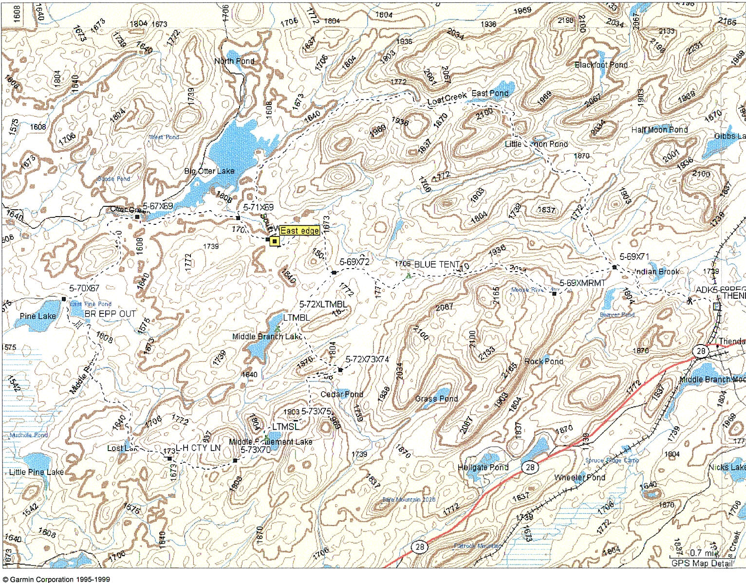
Finally, I hiked the complete loop from the Thendara trailhead that I had planned this summer. I tried this hike back on August 3, but got frustrated and cut it short. So this time I was determined to finish the loop and see the trails. I left work about noon, and got to the trailhead about 2. There was a guy there talking to a couple who were trying to get into their car and leave. As soon as I arrived, they did get in their car and leave. The fellow came over to talk with me. I noticed a camper parked in the yard of the house next to the parking lot, and guessed that it was his. I knew that the Adirondack early archery deer season and the Adirondack muzzle-loader (black powder) deer and bear season opened the next morning, and I figured this fellow was there to do some hunting. Which he confirmed, as he regaled me while I was changing clothes, finishing my packing and getting ready to go. He wanted to know all about where I was going, what each piece of equipment was, etc. He was retired, and probably lonely, but was also holding an empty beer can. Anyway, I was sociable (for a change) until I headed out. Another car loaded with two older couples from Massachusetts arrived while I was preparing, and they headed in for a walk to East Pond (which I thought was more than a walk given the remaining daylight, but off they went.) Here is the map of my route:
Hiking West from the parking lot (THENDARA), [the green names in parentheses indicate waypoints on the map above] I signed in at the trail register (ADK5-69REG). At the point where the East Pond trail breaks away from the Big Otter East Trail (5-69X71) I looked for the water bottles Bob and I hid there on our run in. The water bottled were perfectly hidden, still there, and not opened. I decided to leave them there for the hike out. My plan was to hike into the Middle Branch Lake lean-to Friday, then on to the Pine Lake lean-to Saturday, then hike out either the East Pond trail or the Big Otter East trail on Sunday. The mileages are in the table, below:
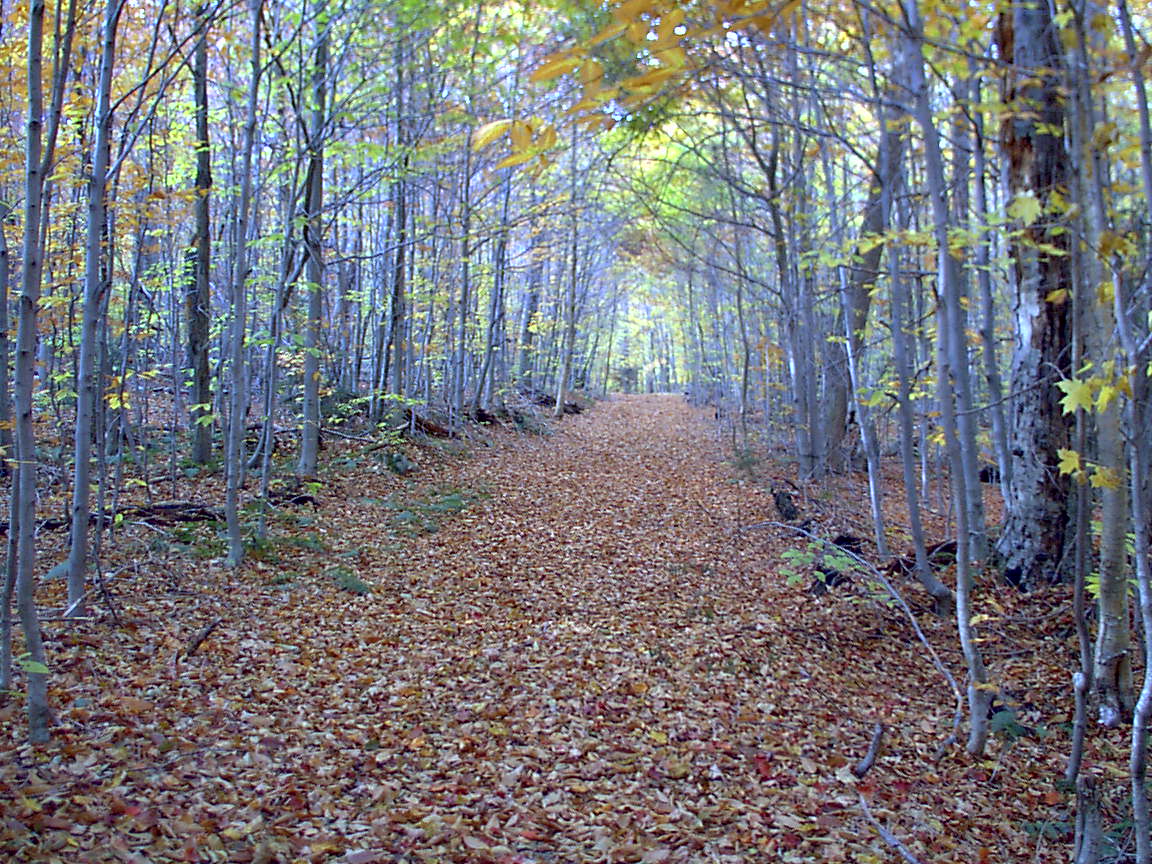
As I was hiking along, enjoying the terrific weather (60s, partly sunny, no rain forecast until evening) I considered the options. I could hike this plan, or I could beat it, by going farther today and then have less far to hike on Sunday. I decided that if the Middle Branch lean-to (LTMBL) was vacant I would spend the night there, but if occupied, I would go on to the lean-to at Cedar Pond. I was partly concerned about the light remaining, but also trying to have options to avoid and unpleasant experience like I had with the night hikers with the dogs. On the trail in, the dry leaves were 4-6" deep, and every step was a rustle of leaves. It was beautiful hiking in. In this section of the forest about 50% of the leaves were down. I met a couple on their walk out a couple of miles into the woods. As I climbed up Moose River Mountain's shoulder, I noticed a huge blue tent (BLUE TENT) off the trail maybe 100 yards to the South (left). I wondered if it was private land, or a DEC work crew, or a hunting party. In any case, I figured they might have guns and decided not to investigate, also trying to keep those daylight options available. This is what the trail looked like:
I made good time, and at 4.85 miles reached the Middle Branch Lake trail (5-69X72) intersection, and headed South. At the lean-to, there were two large packs in the lean-to, and I saw the bearers of those packs way out in the lake in what appeared to be a large aluminum canoe. I have no idea how they got the canoe in there (maybe it was stashed there) but decided that I would head on to the Cedar Pond lean-to indicated on the ADK map and described in the trail guide. This took me to the end of trail 72 and the intersection with trails 73 and 74 (5-72X73X74), another 1.93 miles. Quick reference in the trail guide said to head West a little ways from this intersection to find the lean-to. I walked about an eighth mile and eventually remembered hiking this way on August 4, and also vaguely remembered that I never did see a lean-to. So now that light was getting short, I returned to the intersection and headed west, quickly, on trail 73 for Middles Settlement Lake and the lean-to there (LTMSL). The guide book said 1.5 miles, and it was good hiking, except where the creek was crossed, through a lot of huge boulders, but getting dark quickly. I followed the trail along the shore of the lake, and found the lean-to just as it was getting too dark to see. There, I found two young couples, getting ready to cook their suppers. I asked if they minded if I shared the lean-to with them, and they agreed. I wanted to be in there to keep my equipment dry, even though I had my bivy and a tarp to cover my pack, if I needed them. I hung a bear bag in the dark and then rolled out my sleeping bag in the center of the lean-to, figuring they could sleep either side of me. One couple (let's call them Cliff and Nicole, fictional names) were from Liverpool, and had been there since about 3, and were planning to be joined by friends the next day and spend another night there. The other couple (again, let's call them Mike and Olinda) lived in Brookline, MA, but Olinda had grown up in Onondaga Hill. They were here on a three day weekend, and were going to hike the 3 miles back out to NY28 in the morning and then spend two nights in a Long Lake motel. They had only been there an hour, apparently preceding me from the Middle Branch lean-to. Cliff and Nicole had pitched a tent next to the lean-to. So we each cooked our dinner and talked a little. After that, Cliff built a fire, which he got going fairly well. They had packed in fire-starter logs, since on their previous hike they had used all their matches and paper trying to get a fire started with wet wood. The fire went well, and we sat in the lean-to and talked. I eventually laid down, dozing on and off, while they talked until well past midnight. Cliff and Nicole went into their tent, while Mike and Olinda went for a "walk" in the woods. They were gone for quite a while, and I was wondering if I should be worried for them, but they returned to the lean-to about 1:30. I went back to sleep. It had sprinkled a little during supper, and it rained a little during the night. There didn't seem to be any wildlife around. There was a fairly large and noisy group that arrived about 8:00 at the campsite just south of us. Both Olinda and Cliff and Nicole had brought wine with them. I guess that isn't too surprising, since they only hiked in about 3 miles from their car. Cliff opened a very large (magnum?) bottle of Rose and he and Nicole consumed it. It lasted quite a while, and they talked quite a bit. Mostly about TV survivor shows, etc. I was very satisfied with my day - 8.5 miles in about 3 hours, with a 35 pound pack. I cooked dinner very quickly, and didn't waste much time. I had hiked as far as I could reasonably expect given the timeline, and had the use of a dry lean-to on a rainy night. Not a bad first day! Go on to read about Saturday. |
|
|